

MicaSense Altum Kit
Chance Lawrence2021-06-09T14:09:29-05:00(RE)DEFINING AGRICULTURAL
DRONE SENSING
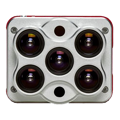
1 SENSOR TO DO THE JOB OF 3
Introducing
THE NEW COMPACT CRP 2
A new compact version of our Calibrated Reflectance Panel (CRP) with the same functionality, now in a smaller size and easier to carry!
The CRP 2 in conjunction with our sensors enables more accurate compensation for incident light conditions. It has known reflectance values across the visible and near-infrared light spectrum.
Capture an image of the CRP 2 before and after each flight to provide an accurate representation of light conditions during the flight!
Manually measuring plant characteristics is time-consuming. Altum captures more data in less time, allowing researchers understand how different breeds react to certain environments and modify desirable traits in order to improve yield.
Altum captures visible and invisible spectral bands, as well as thermal imagery. From the different bands, it is possible to generate indices to detect early signs of crop stress and compare over time. Thermal imagery also provides valuable insights into plant health, since sick plants decrease transpiration and that is reflected into slight temperature changes.
Altum thermal imagery can provide powerful insights into water management, helping identify overspray or missed areas by the difference in crop and soil temperature.
Altum’s thermal imagery can help on the identification of irrigation leaks since water has a cooling effect on the vegetation. Areas with excessive irrigation will appear noticeable cooler than the rest of the field.
Altum not only allows for easy identification of areas low in nutrients but also help monitor the effects of fertilizer applications throughout the season and determine if, when, and where a new application is needed.
By collecting both multispectral and thermal imagery, Altum can identify diseases before symptoms are visible since the early signs of disease are first apparent in the red edge band and can result in small temperature changes.
Altum captures high-resolution imagery that specialized software and algorithms can use to classify plants in a given field by size, species, and canopy closure.
Some differences among species may not be visible to the naked eye. High-quality multispectral data allows for species differentiation by highlighting characteristics such as chlorophyll content, vigor, and leaf size.
High-resolution multispectral data can feed algorithms information for plant counting, saving farmers hours, and making yield predictions more accurate.
Analytics developed with multispectral data can identify and highlight weeds, as weeds may have a different spectral signature than the planted crop.
High-quality multispectral imagery provides advanced field scouting capabilities. In one flight, it is possible to collect accurate and geotagged information of a problem, making easy to assess the situation and determine the appropriate intervention.
One of the advantages of a calibrated multispectral sensor is the generation of aligned outputs, which can be used to create digital surface models (DSM). A DSM provides insights into water management, land uses and terrain elevation.