


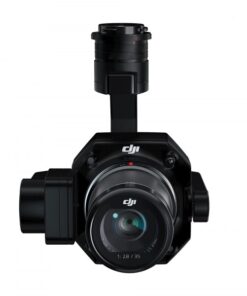
DJI Zenmuse L1 Lidar – Rental

$0.00
- Rent me today! For as low as $110/day (w/ 30-Day rental)
- Basic Liability Insurance included with rental
- Rental Damage insurance available
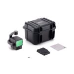
- Rental Includes
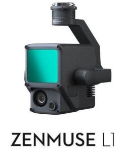
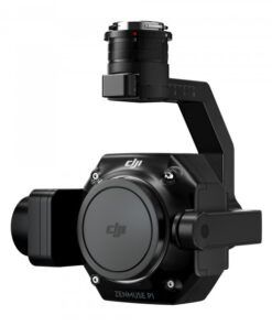
- DJI Zenmuse L1 Lidar
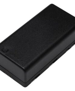
- Storage Case
- 128GB Micro SD Card rental available
- For Matrice 300 / 300 RTK, and newer 350 RTK
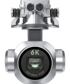
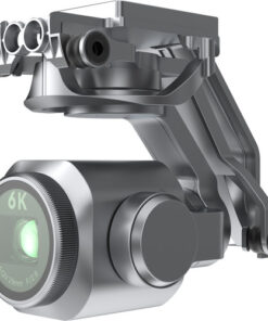
- Lidar Module, 20MP RGB Camera & IMU
- 3-Axis Stabilized Gimbal
- Create Point Clouds in Real Time
- Create Topographical Maps
- Measure Structures for 3D Modeling
- 2″ Vertical & 4″ Horizontal Accuracy
- 240,000 pt/s Point Rate
- IP54 Water & Dust Resistance
Available on backorder
- Description
- Reviews (0)
Description
DJI Zenmuse L1 Lidar – Rental
Introduction to drone rentals by Madison Area Drone Service:
Our goal is to make renting drones & similar equipment an easy, fun and safe experience. We dislike fine print and hidden fees, so all of our agreements and billing fees are easy to understand and easy to view beforehand. Most of all, we want you and everyone else to be safe while you enjoy your rental.
Basic Liability Insurance is included with every rental. If you plan to use your drone for a commercial operation or would like the maximum liability coverage for additional peace of mind, this is available at an additional cost. While the competition leaves you hanging, we make sure you are safe and ready to go before you receive your rental.
Rental Damage Insurance available! In the unlikely event that your rental is crashed, damaged or otherwise brought back in less than perfect shape, don’t worry, you’re covered*. If you really enjoyed your rental and wish you could just keep it, you can! Our Rent-To-Own* program means that your rental fee is applied to the rental purchase, should you choose to purchase the rental unit within 30-days of your last rental date. Deciding on a new drone, or just renting one for fun or to get the job done, has never been more easy and affordable.
*ID & Address verification required for this rental.
Base rental includes what you see pictured.
How it works:
Purchase:
- Select the product options above.
- Add to cart & check out securely online.
- Choose from optional shipping options & checkout.
- We will verify your identity and ship-to address.
- Sign & return the digital E-File Rental Contract & Rental TOS (or sign & return paper copy in-store, local customers only).
Receive:
- Your rental starts once you have received the drone (received = local pickup OR confirmed delivery).
- You’ll receive your rental in person OR by mail.
- Hurray! Get outside and enjoy flying! Your rental will arrive fully charged, updated and ready to go.
Return:
- When your rental time is up, return the drone in person OR drop it off at a shipping store, by the required return time.
- You’ll receive your Refundable Deposit fee back, once the rental is returned on-time & in good condition.
For more information, please read the Drone & Equipment Rental Guide HERE.
For additional terms of service, including rental terms, you can read the full website & rental TOS HERE
*Please read Rental Contract and Rental TOS at the time of rental for completion information.
———————————————————————————————————————————————————————
Instant Clarity. Superior Accuracy.
A Lidar + RGB Solution for Aerial Surveying
The Zenmuse L1 integrates a Livox Lidar module, a high-accuracy IMU, and a camera with a 1-inch CMOS on a 3-axis stabilized gimbal. When used with Matrice 300 RTK and DJI Terra, the L1 forms a complete solution that gives you real-time 3D data throughout the day, efficiently capturing the details of complex structures and delivering highly accurate reconstructed models.
Integrates a Lidar module,
an RGB camera, and a high-accuracy IMU
High Efficiency
2 km2
covered in a single flight
High Accuracy
Vertical Accuracy: 5 cm /
Horizontal Accuracy: 10 cm
Point Rate: 240,000 pts/s
Supports 3 Returns
Detection Range: 450 m
(80% reflectivity, 0 klx)
IP44 Ingress Protection Level
Point Cloud LiveView
Digitize without Compromise

Exceptional Efficiency
Generate true-color point cloud models in real-time, or acquire 2 km2 of point cloud data in a single flight [1] using the Livox frame Lidar module with a 70° FOV and a visible light camera with a 1-inch sensor.

Unparalleled Accuracy
Render centimeter-accurate reconstructions thanks to the high-accuracy IMU, a vision sensor for positioning accuracy, and the incorporation of GNSS data.

Ready When You Are
The IP44 rating allows the L1 to be operated in rainy or foggy environments. The Lidar module’s active scanning method enables you to fly at night.
Visualize Data as You Fly
Livox Lidar Module
– Frame Lidar with up to 100% effective point cloud results
– Detection Range: 450m (80% reflectivity, 0 klx) / 190 m (10% reflectivity, 100 klx)
– Effective Point Rate: 240,000 pts/s
– Supports 3 Returns [3]
– Line Scan Mode and Non-repetitive Scan Mode


Everything in View
RGB Camera
– 20MP
– 1-inch CMOS
– Mechanical Shutter
Accurate Details at Your Disposal
High-accuracy IMU
– Accuracy: 0.025° (roll/pitch) / 0.08° (yaw)
– Vision Sensor for Positioning Accuracy
– GNSS, IMU, RGB Data Fusion

Recreate the World in 3D Point Clouds
Point Cloud LiveView
Real-time point clouds provide immediate insights onsite, so operators are informed to make critical decisions quickly.
You can also verify fieldwork quality by checking point cloud data immediately after each flight.
Measurement and Annotation
Acquire and communicate critical dimensions on the point cloud model using measurements and annotations.

One-stop Post-processing
DJI Terra fuses the IMU and GNSS data for point cloud and visible light calculations, in addition to conducting POS data calculations so you can effortlessly generate reconstructed models and accuracy reports.
Only logged in customers who have purchased this product may leave a review.


Reviews
There are no reviews yet.